St Mary's Church burial ground
Tivetshall St Mary
Norfolk, England
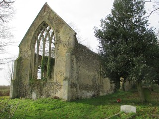
St Mary's Church burial ground, Tivetshall St Mary
The postcode for this church will put you on the village Main Street. From there you need to take the Gissing Road. The church is just a few hundred metres along it by the second bend. The church fell into ruin in the late 1940s when the supersonic boom from a passing military jet caused the tower to collapse. The names on the war memorial are further commemorated on a plaque in nearby Tivetshall St Mary church. For more information about this church visit www.norfolkchurches.co.uk
The GPR holds 123 grave and 176 person records for the burial ground.
The status of the photographing of the burial ground is believed to be complete.
There have been 2892 requests for photographs from the burial ground.
The latest details for the burial ground were added on 16 February 2015