Christ Church's burial ground
Raukokore
East Cape, New Zealand
Christ Church's burial ground, Raukokore
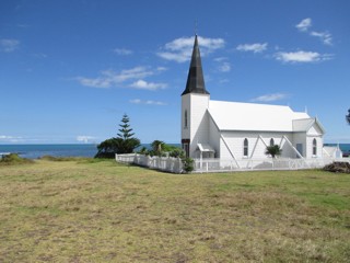
The church is on Route 35 some miles northeast of Opotiki. The mushroom cloud on the horizon, just to the left of the tree, is White Island, it is about 30 miles offshore and is an active volcano. Some of the grave photos could be better but there was a sign asking that only relatives enter the cemetery. I respected this request and took all the photos from outside the perimeter.
The GPR holds 33 grave and 57 person records for the burial ground.
The status of the photographing of the burial ground is believed to be complete.
There have been 2884 requests for photographs from the burial ground.
The latest details for the burial ground were added on 14 November 2014