St Luke's Church burial ground
Westwold
British Columbia, Canada
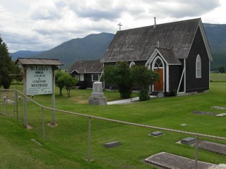
St Luke's Church burial ground, Westwold
Westwold is a small settlement in the southern interior of British Columbia. A small farming and logging community, it is located between Kamloops and Vernon on Highway 97. The original name for the community was “Grande Prairie” but was changed to Westwold in 1928. St Luke’s Church and Cemetery was established in 1898 although a few of the monuments show burial dates before this time. It is still in use today. The cemetery is located on the southwest side of Highway 97 and toward the southeast end of Westwold. The grounds are very well tended, tidy, and enclosed by a chain link fence. Although established on flat land, mountains surround the area on all sides. Highway 97 adjoins the cemetery to the northeast, an elementary school adjoins to the northwest and farm land is located to the remaining two sides.
The GPR holds 211 grave and 255 person records for the burial ground.
The status of the photographing of the burial ground is believed to be complete except inside church.
The quality of the photographs of the burial ground is good.
There have been 2892 requests for photographs from the burial ground.
The latest details for the burial ground were added on 24 July 2011